Sunday 21 October 2018

CHOWEY BRIDGE & COALSTOUN LAKE


The Chowey Bridge

 About 10 km out of town is the railway bridge at Chowey. It seems incongruous to drive down a lonely dirt road and reach a beautifully proportioned concrete arch bridge over a deep pool in the middle of nowhere.
Image result for chowey bridge


 After leaving Chowey Bridge, we drove about 25 km south of Biggenden, where we take another dirt road with  a sign says "lookout" so we take it, off the beaten track, we start  driving along a lovely country-scene road and then all of a sudden the road starts to climb up and the road gets narrow and windy, but there is no where to turn around. Don't look down now! 
We keep following the track and end up coming to a clearing, were we pull up and there is a sign that says 'lookout' and Coalstoun Lakes, we both look at each other and say we have come this far. (It is a late summer afternoon and rather hot.)
 So we lock the car and taking the camera, we start to walk up the steep incline to the first section where there is another sign saying lookout BUT it too is on another steep incline, about 15 minutes later. We are both taken by surprise when we get to the top to find two large crater size hole they are know as "Coalstoun Lake" a non-active volcano.They are surrounded by trees and the centre is  also covered in dense tree foliage.


Harland free camp January 2018


The first night out of Toogoolawah, we went to Harland, which is about 6km east of Yarraman. (S26⁰52'7.6"  -  E152⁰1'28.5") 
January 2018


A quiet spot, except for the bird life, of which there were quite a few, including a dollar bird (Eurystomus orientalis).


This free camp is reasonably large, but no water or power, and the Telstra phone signal is very weak. There are a few walking places and the rail trail is near by. Some might be tempted to jump in the Cooyar Creek for a dip.


This is what is left of the bridge over Cooyar Creek on the old rail line between Blackbutt and Yarraman.


Monday 1 October 2018

HIGHEST TOWN IN QLD RAVENSHOE 29/07/2018 till 19/08/2018


 29th July till 19th August 2018

RAVENSHOE 60km west of Innisfail and 80 km south west of Cairns


 The highest town in Queensland and also the home to the first wind-farm, these tall windmills can be seen from miles away as you approach the highest hill in Ravenshoe. 


Also west of Ravenshoe  you can visit the Little Millstream falls and Big Millstream falls (Australia's widest falls in full flow) east you can take a drive to 
Milla Milla falls.


 A spectacular sight to see there heads amoungst the clouds turning ever so slowly to generate power.


We even had a platypus in our backyard near where the van was parked

Ravenshoe wikipedia

Windfarm wikipedia

Wandering OAP

Playtpus wikipedia

Greg's youtubes


CHILLAGOE LIMESTONE CAVES 03/09/2018


After turning right from the Dimbulah caravan park entrance, we head to Chillagoe about an hours drive, after about 20 minutes we drive through the town of Petford,   
 {remembering not to blink} not much to see in Petford, as not too many people live here now,  the original pub and railway station, both blocked off, a reminder of days gone by.
When you drive out ofthe town of  Petford to Chillagoe the road turns to dirt.


Petford railway station 
 &
local watering hole (Pub)


A tourist train still passes through here twice a week Wednesday and Saturday


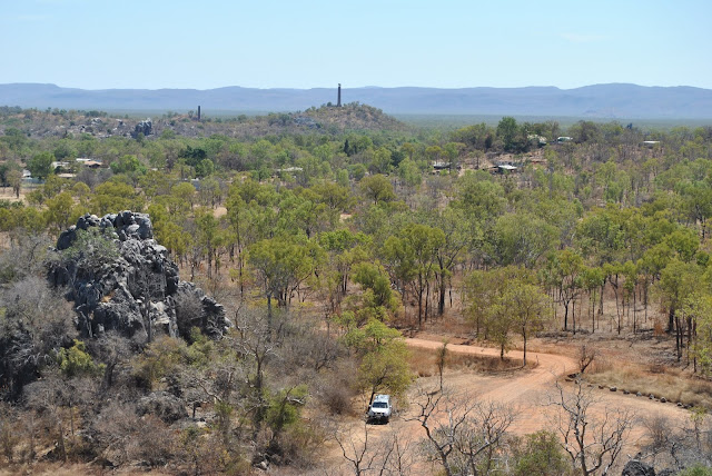
Before heading to the caves we took a detour and viewed the Old Chillagoe smelters
 mining site and three tall chimneys that still remain, 
you cant go near them due to chemicals that were used to process the Ore.This mine was abandoned in 1943


The view from the top entrance to the caves looking down onto the car-park below, where
you have to walk up the concrete pathway and
several levels of steps before getting to the entrance of 
'Trezkinn Cave'. In the past there was no steps and you had to climb up over the rocks.

Chandelier made of limestone droplets  (a)


We visited here on Monday 3rd September 2018
and explored two of the three ranger guided limestone caves, the first cave 'Trezkinn Cave' being the more interesting of the two, the above photo of the chandelier hung from the roof, there was also a  quiet large area inside the cave  where people would come in the past and have a picnic lunch {entered via another entrance which has since been shut off}.


 The second cave 'Royal Arch ' we had to take a special torch with us, {provided by the guide} as there was no lighting inside this cave. This cave tour takes you through 11 chambers and passages.  There was many a section where we had to get down on hands and knees to go under the hanging limestone formations. At one spot we had to turn sideways to get through a section they called 'the squeeze hole', on the other side was a fig tree growing up through the limetone.
We seen unexpected glimpses of darting bats and ancient marine fossils, well worth the effort.

Fig tree


In one section we had to crouch down to almost being on our knees crawling to get through a section they call the squeeze hole to  discover a beautiful items hanging from the roof.


as well as doing a self guide tour outside around the hanging rocks all being uniquely different. 


Ranger guided cave tours

Chillagoe wikipedia

Chilligoe smelters wikipedia
  
Petford wikipedia

Wandering OAP

Greg's youtube


Dimbulah Caravan Park


For those who would like to see what the Dimbulah caravan park looks like now?


When you view the video please like it.

The Wandering OAP
his youtube channel